The tectonic system involves the movement of the lithosphere, which is broken into a mosaic of separate plates.These plates move independently, separating, colliding, and sliding past one another.The margins of the plates are sites of considerable geologic activity, such as seafloor spreading, continental rifting, mountain building, volcanism, and earthquakes. Geologists have long recognized that Earth has its own source of internal energy. It is repeatedly manifested by earthquakes, volcanic activity, and folded mountain belts. But it was not until the middle 1960s that a unifying theory developed to explain Earth’s dynamics.This theory, known as plate tectonics, provides a master plan of Earth’s internal dynamics. The term tectonics, like the related word architecture, comes from the Greek tektonikos and refers to building or construction. In geology, tectonics is the study of the formation and deformation of Earth’s crust that results in large-scale features. Evidence for this revolutionary theory of lithospheric movement comes from many sources. It includes data on the structure, topography, and magnetic patterns of the ocean floor; the locations of earthquakes; the patterns of heat flow in thecrust; the locations of volcanic activity; the structure and geographic fit of the continents; and the nature and history of mountain belts.
The basic elements of the tectonic system are simple and can be easily understood by carefully studying Figure 1.The lithosphere, which includes Earth’s crust and part of the upper mantle, is rigid, but the underlying asthenosphere slowly flows. A fundamental tenet of plate tectonics is that the segments, or plates, of the rigid lithosphere are in constant motion relative to one another and carry the lighter continents with them.
Plates of oceanic lithosphere form as hot mantle material rises along midoceanic ridges; they are consumed in subduction zones, where one converging plate plunges downward into the hotter mantle below (Figure 1).The descent of these plates is marked by deep-sea trenches that border island arcs and some continents. Where plates slide by one another, large fractures form.The movement and collision of plates accounts for most of Earth’s earthquakes, volcanoes, and folded mountain belts, as well as for the drift of its continents.
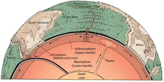
Figure 1 The tectonic system is powered by Earth’s internal heat.The asthenosphere is more plastic than either the overlying lithosphere or the underlying lower mantle. Above the plastic asthenosphere, relatively cool and rigid lithospheric plates split and move apart as single mechanical units (along the ocean ridges). As this happens, molten rock from the asthenosphere wells up to fill the void between the lithospheric plates and thus creates new lithosphere.Very slow convection occurs in the mantle. Some plates contain blocks of thick, lower-density continental crust, which cannot sink into the denser mantle. As a result, where a plate carrying continental crust collides with another plate, the continental margins are deformed into mountain ranges. Plate margins are the most active areas on Earth the sites of the most intense volcanism, seismic activity, and crustal deformation. Locally, convection in the deep mantle creates rising mantle plumes. (After P. J. Wyllie)
From the standpoint of Earth’s dynamics, the boundaries of plates are where the action is. As seen in Figure 2, plate boundaries do not necessarily coincide with continental boundaries, although some do.There are seven very large plates and a dozen or more small plates (not all of which are shown in Figure 2). Each plate is as much as a few hundred kilometers thick. Plates slide over the more mobile asthenosphere below, generally at rates between 1 and 10 cm per year. Because the plates are internally quite rigid, they become most deformed along their edges. The basic source of energy for tectonic movement is believed to be Earth’s internal heat, which is transferred by convection. In a simple model of Earth’s convecting interior, hot mantle material rises to the lithosphere’s base, where it then moves laterally, cools, and eventually descends to become reheated, continuing the cycle. A familiar example of convection can be seen while heating a pot of soup. Heat applied to the base of the pot warms the soup at the bottom, which therefore expands and becomes less dense.This warm fluid rises to the top and is forced to move laterally while it cools. Consequently, it becomes denser and sinks, setting up a continuing cycle of convection.
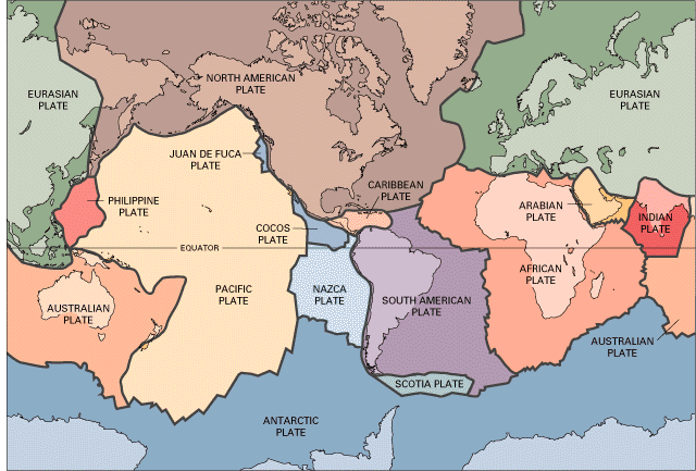
Figure 2. A mosaic of plates forms Earth’s lithosphere, or outer shell.The plates are rigid, and each moves as a single unit.There are three types of plate boundaries: (1) the axis of the oceanic ridge, where the plates are diverging and new oceanic crust is generated ; (2) transform faults, where the plates slide past each other (the short lines slicing across the divergent boundaries); and (3) subduction zones, where the plates are converging and one descends into the asthenosphere.
Let us look briefly at the major features of the planet and how they fit into the tectonic system.The different types of plate boundaries are, in effect, subsystems of the tectonic system. Each creates specific geologic phenomena. We have illustrated each boundary type with an example from the continents.
it is largely concealed below sea level.When oceanic earthquake locations are plotted on a map, they outline with dramatic clarity the divergent plate boundaries (Figure 4). Most of these are shallow earthquakes, quite unlike those found where plates converge. Most divergent boundaries occur on the seafloor, but continental rifts also develop where divergent boundaries form on the continents. Such a continental rift eventually creates a new ocean basin. The great rift of the Red Sea displays many features of a continental rift. The Red Sea is an extension of the midoceanic ridge of the Indian Ocean, which splits the Sinai and Arabian peninsulas from Africa. Take the time to locate the area shown in this remarkable photograph on the topographic map on the inside covers of this book. The structure of the area is dominated by the long, linear fault valley that forms the north end of the Red Sea and Gulf of Suez. Note the sharp contrast where faults have juxtaposed young, light-colored sediments against the ancient shields as this region is slowly ripping asunder. New seafloor is forming on the floor of the Red Sea.This rift expresses dramatically the tensional stresses in the lithosphere and the way these stresses affect Earth’s surface.
Figure 3 Convection in the mantle can be compared to convection in a pot of soup. Heat from below causes the material to expand and thus become less dense.The warm material rises by convection and spreads laterally. It then cools, and thus becomes denser, and sinks. It is reheated as it descends, and the cycle is repeated.
Transform Plate Boundaries. The oceanic ridges are commonly broken and offset along lines perpendicular to the ridges. These offsets are large faults expressed by their own high ridges and deep valleys.Transform plate boundaries occur where plates horizontally slide past one another (Figure 6). Shallow earthquakes are common along all transform boundaries (Figure 4), but volcanic eruptions are uncommon. Most transform plate boundaries are on the seafloor, but the best-known example of this type of fault on a continent is the great San Andreas Fault system in California (Figure 6).The fault zone is marked by sharp linear landforms, such as straight and narrow valleys, straight and narrow ridges, and offset stream valleys. The San Andreas Fault system is an active boundary between the Pacific plate to the west and the North American plate to the east.The Pacific plate is moving at about 6 cm per year, relative to the North American plate. As stress builds between the plates, the rock bodies deform until they break. This sudden release along the fault causes earthquakes like those so common in California. Another transform boundary cuts the Asian continent from the Gulf of Aqaba to the Dead Sea and creates a valley obvious from space.
Convergent Plate Boundaries. Plates move toward one another along convergent plate boundaries. Along such plate margins, geologic activity is far more varied and complicated than at transform plate boundaries . Intense compression ultimately rumples the lithosphere and builds high folded mountain belts. Preexisting rocks become altered by heat and pressure.The net result is the growth of continents.Where two plates converge, one tips down and slides beneath the other in a process known as subduction. It is clear that earthquakes and volcanoes dramatically outline convergent plate margins (Figure 4).The simplest form of convergence involves two plates with oceanic crust. Such subduction zones in the western and northern Pacific region lie along the volcanic islands of Tonga, the Marianas, and the Aleutians.Trenches form where the downgoing plate plunges into the mantle.These are long, narrow troughs, normally 5 to 8 km deep, and are the lowest features on Earth.As a plate of lithosphere slips into the mantle, it becomes heated and dehydrated. Some rock material melts, becomes less dense, and rises, and some erupts to form a string of volcanic islands called an island arc. If the oceanic plate dives beneath a continent, the molten rock may form a chain of volcanoes on the continental margin; the Cascades of California-Oregon- Washington are an example. The remarkable series of deep-sea trenches and associated volcanic arcs make the “ring of fire” that almost surrounds the Pacific Ocean (Figure 4). As each subducting plate grinds its way downward, earthquakes are produced. The deepest of all earthquakes, almost 700 km deep, occur at convergent plate boundaries. Plate tectonics can thus readily explain why the Andes mountains of South America are tormented by repeated volcanic eruptions and earthquakes.They are forming where two tectonic plates converge.The same is true for the western coasts of Central America. It is equally clear that the earthquakes and volcanic eruptions in the Mediterranean area occur at a convergent plate margin. Where moving plates converge, the rocks in the crust may also become deformed. The crust in continents and in island arcs is buoyant (it is less dense than oceanic crust) and resists subduction back into the dense mantle. Consequently, this kind of crust becomes intensely compressed and folded at some convergent plate margins. The structures of the Andes Mountains of South America vividly express this type of deformation. The complex system of ridges and valleys in the eastern Andes is produced by folded sedimentary rock layers deformed by the collision of two plates.The folded layers now appear like wrinkles in a rug. The Appalachians were formed in a similar manner . A younger mountain belt that extends from Alaska through the Rockies and Central America and into the Andes of South America was produced by the encounter of the American plates with the Pacific, Cocos, and Nazca plates.This is a geologically young mountain system, with many parts still being deformed as the plates continue to move.
Within-Plate Tectonics and Mantle Plumes. Within the moving plates, the continental and oceanic crust experience little tectonic or volcanic activity as they move away from midoceanic ridges. However, plumes of hot rock rising from the deep mantle (Figure 1) may create isolated volcanoes and gently warp the interior
of a plate.An excellent example is the Hawaiian Island chain in the Pacific Ocean. The huge volcanoes and geysers of Yellowstone National Park in western North America may also overlie a mantle plume. Earthquakes related to the volcanoes in these areas are also common (Figure 4), but large deep earthquakes are rarely felt in such within-plate regions.

Figure 4 Earthquakes and active volcanoes outline plate margins with remarkable fidelity. At divergent plate boundaries, shallow earthquakes, submarine volcanic eruptions, and tensional fractures occur.Transform boundaries have shallow earthquakes but generally lack active volcanoes. Along convergent margins, there are deep earthquakes, volcanic eruptions, trenches on the seafloor, and folded mountain belts. Isolated areas of volcanism and earthquakes reveal the locations of active mantle plumes.

Figure 5 The Mid-Atlantic Ridge is a divergent plate boundary and marks the spot where new lithosphere is forming and where two plates are separating.The North American plate is slowly moving west and Africa on the Eurasian plate is moving east. Earthquakes and volcanoes are concentrated along the crest of the ridge Transform faults cut the ridge and offset it. (Courtesy of Ken Perry, Chalk Butte, Inc.)
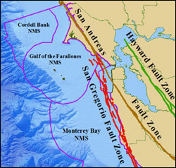
Figure 6 The San Andreas Fault system in California is part of a long transform plate boundary that separates the North American plate from the Pacific plate. It connects a divergent boundary in the Gulf of California with the Mendocino transform fault and the Juan de Fuca ridge. At least a dozen major fault systems can be seen as linear mountain trends. Movement along the San Andreas Fault is horizontal; that is, one block of Earth’s crust slides laterally past another. (Courtesy of Ken Perry, Chalk Butte, Inc.)
Direct referensi : W. Kenneth Hamblin & Eric H. Christiansen, Earth's Dynamic System (Tenth Edition),